Social Housing History: The London County Council
The early history of social housing in Britain
Forming the county of London
It comes as a surprise to many people that London, as a county, did not exist until 1889. Before that most of what people know as “London” was in the counties of Middlesex and Surrey. For example, Southwark was in Surrey and Stepney was in Middlesex. The City of London was a small self-administrative area that was never part of any county, and remains so today.
The County of London came into being on 21st March 1889 and was administered by the London County Council (always shortened to LCC) who took over the management of roads, drainage, fire services, community health (including slum clearance) and, by 1904, education and trams. Most of these services had previously been managed by the Metropolitan Board of Works (MBW) and the LCC was, in the early days, a simple replacement using the same staff and taking over their headquarters, Spring Gardens, off Trafalgar Square. The main difference between the MBW and LCC was that the latter was politically aligned and the main officers were elected. Apart from elected officers, the LCC had to appoint a Chairman as leader and the first was an inspired choice; Archibald Primrose, 5th Earl of Rosebery. The Earl decided not to interfere with the day-to-day work of the elected officers and just provided guidance and support. As a result, the Council progressed with its “Liberal” aims with particular advantage to the Housing Department.
The Housing Department was led by experienced men who employed young architects who were given scope to develop the Council’s buildings, whether housing, fire stations or public buildings. The county did not have limitless funds; far from it. The County had to justify all spending and their housing was expected to make an annual profit, through rents, of 5%. This led to a conflict between the architects, who wanted to build modern and healthy buildings, and the London rate payers who wanted everything to be built as cheaply as possible, if built at all. Sometimes it was successful, sometimes a careful balance, and sometimes the numbers simply did not add up.
In 1907 the “Progressives” lost control of the Council and the “Municipal Reformers” took over. They were aligned to the Conservatives and no more building schemes were started before WW1. To their credit though, all schemes in the planning and building stages were continued and completed.
The sub-menus above give more detail on the early days of the LCC, and the financial and legislative environments in which the architects worked. This is followed by details on every housing scheme undertaken by the LCC before World War 1. All building stopped in WW1 but the three garden estates under construction were completed when hostilities stopped. Little social housing was started after WW1, despite government campaigns such as “Homes fit for heroes” and various Acts.
London before the LCC
To understand the housing needs of the workers of London it is important to know about London and its demographics at the time of the county formed. Who were the people, what were the building laws and what was the LCC’s challenge in attempting to house them?
Read > Paper part 1: Setting the scene. London and its housing before the LCC
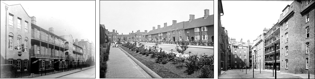
It is also important to know about the LCC architects and their influence on the designs. Many were advocates of William Morris’ Arts and Crafts Movement. The pre-WW1 designs have artistic touches both inside and out that visually lifted many large blocks of tenements away from being very plain and “barracky”. However, these architects had to design blocks (and later, garden estates) to house a minimum number of people, in a location that was not of their choice, and to a budget that would permit the Housing Department to make a profit of 5% per annum from rents that were fixed at values for similar property in the area. This was a difficult task for architects who wanted to build quality buildings that they could be proud of. Sometimes they could only achieve this through reducing the cost of the design, which was not to their liking. In a number of cases the Housing Department knew that they could never make a profit but knew (or, maybe, hoped) that other housing schemes would be profitable and they could use those profits of one to offset the losses of another. All the housing had to be funded from government loans which would be paid back over 60 years from a Sinking Fund that was fed from the rents collected (once the significant running costs had been allowed for). The financial officers of the time needed to be quite creative with their methods of balancing the books. To the credit of the Housing Department most of the blocks built, and all four of the pre-WW1 Garden Estates, were to a high standard and generous proportions. The fact that much of the pre-WW1 housing remains, modernised many times, is the evidence of their success at this. Read about the architects and how the funding worked.
Read > Paper part 2: The LCC, its architects and the financial environment in which they operated
The LCC’s Early Housing – 1889 to 1914
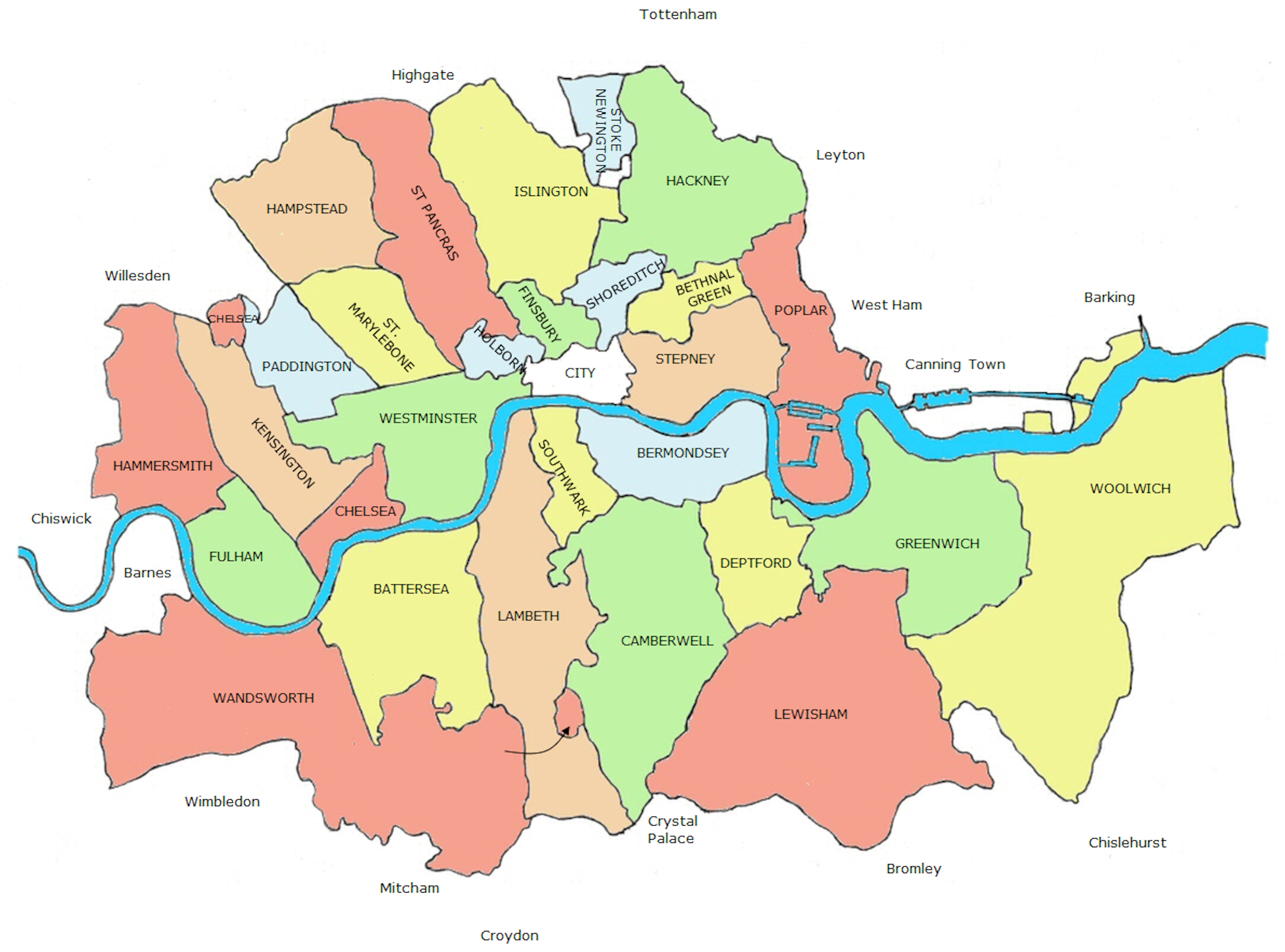
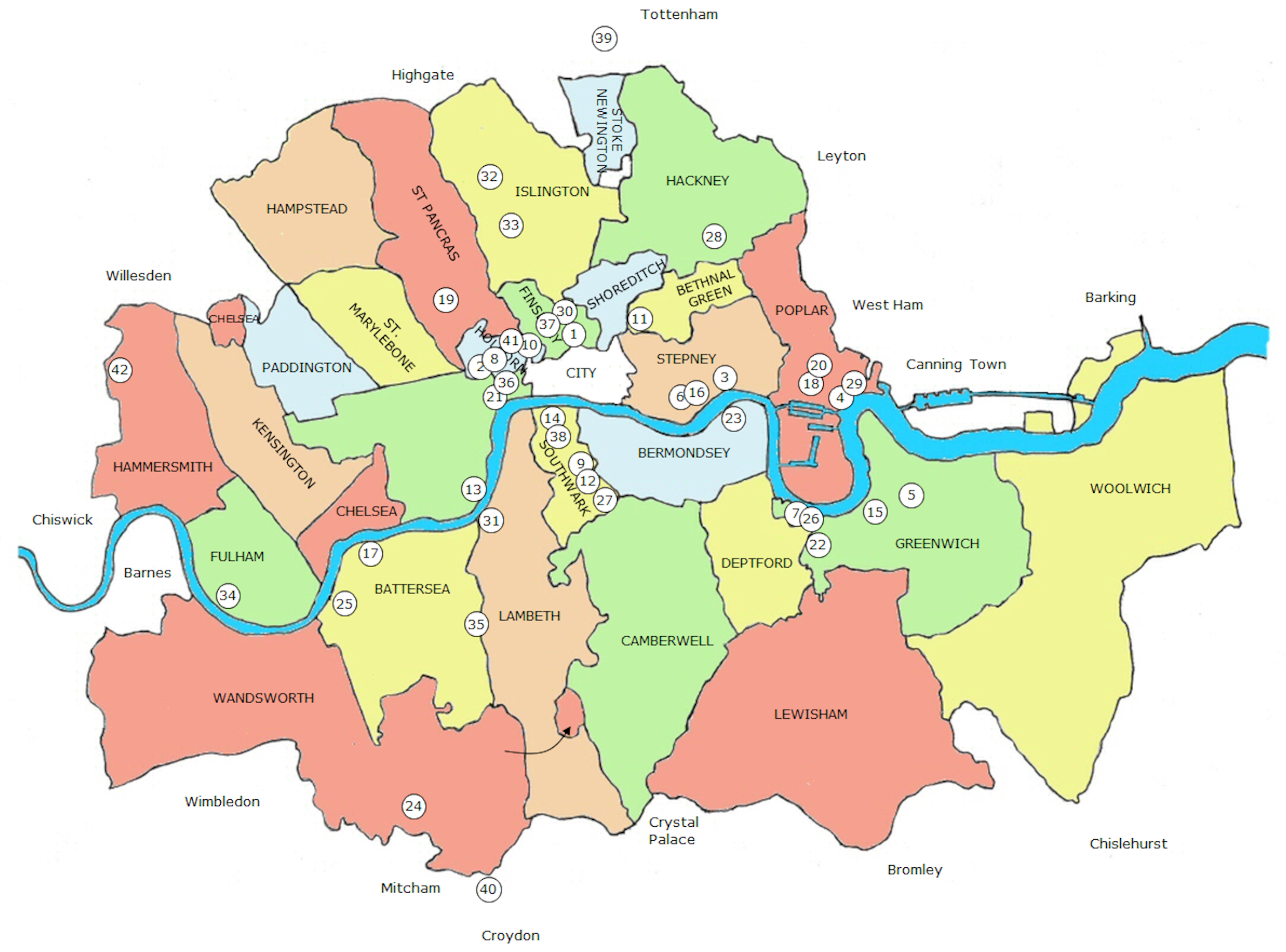
The map below is the LCC boundary and the post-1899 London Boroughs. Each number represents a development, in sequence, of all housing schemes started by the LCC between 1889 and 1914. Use the table below the map to download the description of each scheme.
If you do not know the name of the sceme under which a particular building was constructed, use the cross-reference link in the menus to identify the building name.
LCC Building cross-reference
The LCC schemes covered in previous pages rarely give a clue as to the names of the blocks of housing that were built as a result. To help you identify the correct document that covers the construction of specific buildings, use the table below. Click on the “LCC scheme” to download the individual write-up of the scheme concerned. In a few cases the name of the building has changed from that given by the LCC when built, so check the contents of the downloaded paper if it seems to cover buildings of different names.
| Building Name | LCC Scheme (click to view PDF) |
|---|---|
| Abingdon Buildings | Boundary Street |
| Adelaide Buildings | Ann Street |
| Albury Buildings | Green & Gun Street |
| Aldwych Buildings | Shelton Street – Phase 2 |
| Algar Buildings | Webber Row |
| Armitage Cottages | Blackwall Tunnel – South |
| Baffin Buildings | Burford/Tuckers Court |
| Barnaby Buildings | Long Lane & Tabard St |
| Battersea Bridge Bldgs | Battersea Bridge |
| Beachcroft Buildings | Brook Street |
| Bearcroft Buildings | Fulham Palace Road |
| Beaumont Buildings | Clare Market & Strand |
| Bekesbourne Buildings | Rotherhithe Tunnel |
| Benbow Buildings | Hughes Field – Phase 2 |
| Benson Buildings | Boundary Street |
| Bewley Buildings | Cable Street – Phase 1 |
| Brightlingsea Buildings | Rotherhithe Tunnel |
| Briscoe Buildings | Briscoe Buildings |
| Bruce Buildings | Caledonian Estate |
| Bruce House | Clare Market – Phase 2 |
| Buckridge Buildings | Aylesbury Place – Phase 2 |
| Burns Buildings | Caledonian Estate |
| Carrington House | Mill Lane |
| Chadworth Buildings | Garden Row & Roby St |
| Chancery Buildings | Cable Street – Phase 2 |
| Chertsey Buildings | Boundary Street |
| Clandon Buildings | Green & Gun Street |
| Clere Cottages | Nine Elms |
| Cleve Buildings | Boundary Street |
| Clifton Buildings | Boundary Street |
| Cobham Buildings | Falcon Court |
| Collerston Cottages | Blackwall Tunnel – South |
| Cookham Buildings | Boundary Street |
| Coram Buildings | Clare Market & Strand |
| Cotterell Buildings | Shelton Street – Phase 2 |
| Council Buildings | Blackwall Tunnel North |
| Cranford Cottages | Brook Street |
| Cranley Buildings | Brooke’s Market |
| Culham Buildings | Boundary Street |
| Darcy Buildings | Mare Street |
| Dauncey Buildings | Webber Row |
| Delarch Buildings | Webber Row |
| Dellow Buildings | Cable Street – Phase 1 |
| Denys Buildings | Clare Market & Strand |
| Dickens Buildings | Clare Market & Strand |
| Drakes Buildings | Hughes Field – Phase 2 |
| Dufferin Court | Dufferin Street |
| Durham Buildings | Durham Buildings |
| Fletcher Buildings | Clare Market & Strand |
| Frewell Buildings | Clare Market & Strand |
| Gainsborough Bldgs | Millbank |
| Gardiner Buildings | Falcon Court |
| Goldsmith Row Cotts | Boundary Street |
| Hardy Cottages | Trafalgar Road |
| Hedsor Buildings | Boundary Street |
| Henley Buildings | Boundary Street |
| Hogarth Buildings | Millbank |
| Holmwood Buildings | 97 Southwark Street |
| Hudson Buildings | Burford/Tuckers Court |
| Hunter Buildings | Falcon Court |
| Hurley Buildings | Boundary Street |
| Hythe Buildings | Rotherhithe Tunnel |
| Idenden Cottages | Blackwall Tunnel – South |
| Iffley Buildings | Boundary Street |
| Kirkeby Buildings | Aylesbury Place – Phase 2 |
| Knox Buildings | Caledonian Estate |
| Laleham Buildings | Boundary Street |
| Landseer Buildings | Millbank |
| Laney Buildings | Aylesbury Place – Phase 2 |
| Lawrence Buildings | Millbank |
| Ledham Buildings | Clare Market & Strand |
| Leighton Buildings | Millbank |
| Lennox Buildings | Nine Elms |
| Lewisham Cottages | Hughes Field – Phase 1 |
| Building Name | LCC Scheme (click to view PDF) |
|---|---|
| Lindsay Buildings | Shelton Street – Phase 2 |
| Lowood Buildings | Cable Street – Phase 2 |
| Maclise Buildings | Millbank |
| Mallory Buildings | Aylesbury Place – Phase 1 |
| Marlow Buildings | Boundary Street |
| Mawdley Buildings | Webber Row |
| Melbourne Buildings | Ann Street |
| Melchester House | Wedmore Street |
| Mereton Mansions | Mill Lane |
| Merrow Buildings | Green & Gun Street |
| Millais Buildings | Millbank |
| Molesey Buildings | Boundary Street |
| Montreal Buildings | Blackwall Tunnel North |
| Morland Buildings | Millbank |
| Mulready Buildings | Millbank |
| Murphy Buildings | Falcon Court |
| Nigel Buildings | Aylesbury Place – Phase 2 |
| Northcombe House | Wedmore Street |
| Ontario Buildings | Burford/Tuckers Court |
| Ottawa Buildings | Burford/Tuckers Court |
| Overy Buildings | Webber Row |
| Parker Street Lodging | Shelton Street – Phase 1 |
| Powis Buildings | Shelton Street – Phase 2 |
| Quebec Buildings | Burford/Tuckers Court |
| Radcliff Buildings | Clare Market & Strand |
| Raleigh Buildings | Hughes Field – Phase 2 |
| Redman Buildings | Clare Market & Strand |
| Reynolds Buildings | Millbank |
| Ripley Buildings | Green & Gun Street |
| Romney Buildings | Millbank |
| Rossetti Buildings | Millbank |
| Ruskin Buildings | Millbank |
| Rye Buildings | Rotherhithe Tunnel |
| Sandford Buildings | Boundary Street |
| Sandwich Buildings | Rotherhithe Tunnel |
| Seaford Buildings | Rotherhithe Tunnel |
| Scott Buildings | Caledonian Estate |
| Scrope Buildings | Clare Market & Strand |
| Seaford Buildings | Rotherhithe Tunnel |
| Seymour Buildings | Churchway |
| Shene Buildings | Clare Market & Strand |
| Sheridan Buildings | Clare Market & Strand |
| Shiplake Buildings | Churchway |
| Siddons Buildings | Boundary Street |
| Skipwith Buildings | Clare Market & Strand |
| Somerset Buildings | Clare Market & Strand |
| Sonning Buildings | Churchway |
| St Lawrence Cotts | Boundary Street |
| Stirling Buildings | Burford/Tuckers Court |
| Streatley Buildings | Clare Market & Strand |
| Sunbury Buildings | Boundary Street |
| Sydney Buildings | Boundary Street |
| Sylva Cottages | Ann Street |
| Taplow Buildings | Mill Lane |
| Thackeray Buildings | Boundary Street |
| Toronto Buildings | Clare Market & Strand |
| Turner Buildings | Blackwall Tunnel North |
| Union Buildings | Millbank |
| Valette Buildings | Aylesbury Place – Phase 2 |
| Wallace Buildings | Mare Street |
| Walton Buildings | Caledonian Estate |
| Wargrave Buildings | Boundary Street |
| Wellesley Buildings | Boundary Street |
| Wenlake Buildings | Churchway |
| Wessex Buildings | Garden Row & Roby St |
| Wessex House | Wedmore Street |
| Westview Cottages | Wedmore Street |
| Wetherbury House | Blackwall Tunnel – South |
| Wilkie Buildings | Wedmore Street |
| Wimbledon Buildings | Blackwall Tunnel – South |
| Winchelsea Buildings | Shelton Street – Phase 2 |
| Winnipeg Buildings | Rotherhithe Tunnel |
| Winsham House | Burford/Tuckers Court |
| York Street Buildings | Churchway |
